Flight Logging and Statistics
Introduction
Logging of flight data for flights performed in a flight simulator
seems to overshoot the purpose of the hobby. Some people
might think so, but for me the logged data is a
indispensable source for
reviewing past activites and making decisions for future
leg planning and procedure trainings. In combination
with Google Earth it even gives added value for the
hobby and closes the gap to the real world.
mccPILOTLOG
After a while of on-line flying with IVAO I started
to record my flight. I did this by handwriting in a
flight log book from Jeppesen. This worked great for
a year or so, but the drawback was not to get
statistics just by pressing a button. Therefore I
decided to upgrade and bought a licence of
mccPILOTLOG. The program is very well designed and
fulfills all my requirements. Whatever question you
have or whatever data you need, query the database
with a few clicks and get the results within a
second. There are also many standard reports
pre-coded and available with a few 'clicks'.
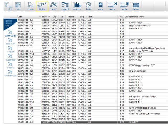
Excerpt from the upper part of the flights
logging page
- Top 20 Desination Report click 'here'
- Destinations Report click 'here'
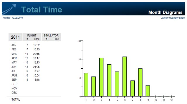
Month Diagram of logged flights and hours (bock time)
Click the item to expand the diagram
Links:
mccpilotlog:
http://www.mccpilotlog.net/screenshots.html
Save Your Flights
Another way of logging flights
is offered by the an Internet based application
called 'Save Your Flights'. The application requires
the installation of a small program on your local
computer. The program records all relevant flight data
(including taxi procedures). After completing the flight you
can transfer the flight data to the Save Your
Flights internet application. All your flights will
be stored there and available for you, but also for
other registered people. The most impressive thing
is, that the flight can be overlayed on Google
Earth. This works very accurate and you can see the
gate you started, the taxi path, and the flight path
with altitude profile. It's amazing and demonstrates how close
flight simulation can be to the real world.
Remark: If the program runs on a other computer than on the FS server, make sure that a widefs client is installed on that PC.
The program collects the following data:
|
- Depature
- Offblock-time |
- Type of aircraft
- Fuel consumption |
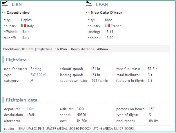
Example of a flight from Naples (LIRN) to Nice (LFMN).
The planed flight route and some other flight plan
data is collected from IVAO or VATSIM respectively.
Flight Simulation meets
real world
Click 'here' and download a kml file for
Google Earth. The data was recorded with 'Save your
Flights' during a flight from Bremen (EDDW) to
Berlin Schoenefeld (EDDB).
-
The flight started at gate 4 at EDDW
- Taxi via C and
F to holding point rwy 27
- GESTO3A GESTO Z870 BKD L619 VIBIS VIBIS2Z
-
Landing on rwy 25 in EDDB.
- Taxi via A, K and H to gate 54.
Remark:
Make sure that you have
Google Earth properly installed on your computer and
that the kml MIME type at your internet browser is
assigned to Google Earth.
Links:
Save your Flight:
http://www.saveyourflight.de/index.php?